If we are to be successful in using the notion of ganma to mediate between the knowledge-power networks that constitute the rivers of contemporary life in Australia, we need a leap of the imagination to stand back from ourselves. In order to shatter the aura of inevitability which surrounds the practices by which land is understood and controlled, and boundaries made and remade, we must try to create a strangeness around such proceedings. In the rest of this exhibit, the two systems of perceiving and manipulating land are examined. The aim is to show some of the sophistication and rationale, the cultural embeddedness, the strengths and weaknesses, of each. In the end both systems rely on metaphor, but the types of metaphor and the ways in which metaphor itself is regarded and used are quite different.

5.5
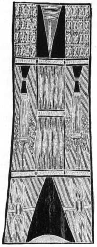
Fresh water lobsters; moiety - Yirritja; clan - Wangurri; painter - Muŋandjiwui Munyarryan, 1986, ochre on bark, 121 x 43 cm.
This bark is a text which encodes political and religious meanings; it can be read at many levels. Here is the story of the Ancestors in the form of maypal - crustaceans. Through journeying from one place to another the Ancestors established clans related in a foundational sense. A log infiltrated with larval crustaceans floats down a river (Europeans call this the Buckingham River) into the salt water (Buckingham Bay). On being washed up on an island the lavae hatch, thereby constituting the foundation of another Yolngu clan.
In the top panel we see the maypal in the log. They are the babies of the gätuŋ (the fresh water lobsters we see in the central panel). The log travels down the river to the salt water of the sea, eventually being washcd up on an island; the maypal hatch baby lobsters, which we see in the bottom panel.
Two important concepts are encoded in this metaphoric text: the notion that clans are linked in particular ancestral ways, and the notion of dialectic implied in the meeting of fresh and salt water.

5.6
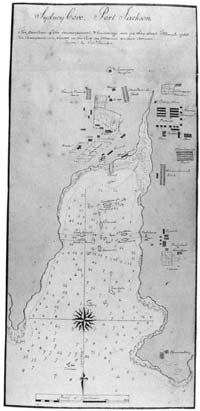
Sketch map of Sydney Cove, Port Jackson, showing boundaries which had been established by Europeans within two months of their arrival.
What are these things 'length', 'area' and 'number' by which Westerners so confidently assume that 'objective' sections of land are created, which are easily legitimated in their social order? Such notions are used and rarely given a second thought. They are assumed 'really' to exist because they are used. But do they? Is it not the case that their being used conjures them into existence? Of course it would never do to admit that these things by which Westerners create order and pattern in their world are not 'real'. A 'real' basis is needed in which to ground things like land ownership. Westerners, like all peoples, have a great need to invest their arrangements with solidity and 'naturalness', so that they can be used, with 'objectivity'. Westerners reify them and, though they are in the end metaphors, invest in them an ontological priority as real manifestations of the world.
How might Westerners explain the meaning of abstract qualities like length and area? Indeed Yolngu people often ask this question of their English-speaking compatriots. The stock answer is 'You can see the length and the area of land'. A native English speaker might say 'See, from here to that stringy bark tree is the length of the property, now come across to that big yellow box tree, that's the width, so now you can see the area'. The confused questioner might with some justification, reply 'I see only the land with its grasses and trees. These things length, width and area are not there in the land to be seen!' They are visual metaphors. They are elusive and mysterious things, and so Westerners objectify and naturalise them. They are not 'facts of nature', they are 'social facts', made in talk and practice, then used in good faith as real things to construe land as divided into units. Using these qualities and the number pattern together, sectioned units of land are created. In this way land enters Western social life, reduced to inscriptions on papers which are held safe in the Titles Office.
ITEM 5.6 is a sketch map showing the internal boundaries which had been established within three months of European arrival on these shores. We can imagine fences made of saplings and ditches dug. We can imagine too that people would have utilised short sticks and string to get the circles circular, the sides of the rectangles equal and the angles between them right. This map constitutes a record of who had the rights to use what plots and for what purposes. It is an early form of written entitlement to units of land. The boundaries we see recorded on this map were signified and their significance was recorded.
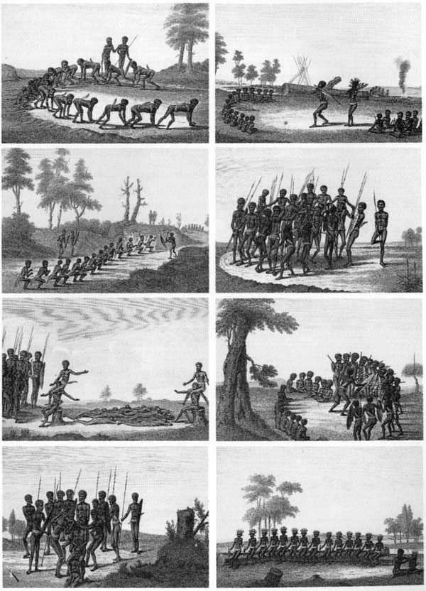
While the newly arrived Europeans were busy thus signifying boundaries, so too were those who would in the end be dispossessed of their land: the Eora people of the place the Europeans called Port Jackson. The dance sequence we see recorded with such commendable detail in ITEM 5.7 is the text of a boundary signification. It may well refer to the very land which is depicted in the sketch map of Sydney Cove. It was recorded in 1788 at the very same time as the Europeans were establishing and recording their boundaries.
The dance so woodenly captured and the song which would have accompanied its elaboration delimit a unit of land through singing and acting out a narrative. Here we see a quite different form of metaphor, a narrative which records the investment of a particular named unit of land in a particular named set of people. It summons up the way in which the world was made meaningful by the doings and journeys of the Ancestors. It reminds those who have been properly instructed of the signs of the Ancestors' living which are to be seen in the landscape. The dance and song alluded to here assert title to a unit of land and conjure up a set of boundaries which were constituted in a knowledge-power network contesting and conflicting with the knowledge-power network within which the Sydney Cove map and the boundaries it records had life.

5.7
J. Neagle, Yoo long erah-bah-diang, ?1798 engraving
Rex Nan Kivell Collection, National Library of Australia, Canberra.
A dance sequence recorded in 1788. This dance documents the investment of a particular section of land in a particular group of people.
The dance, however, is just one of the forms of text by which title to land is asserted and confirmed in Aboriginal Australia.